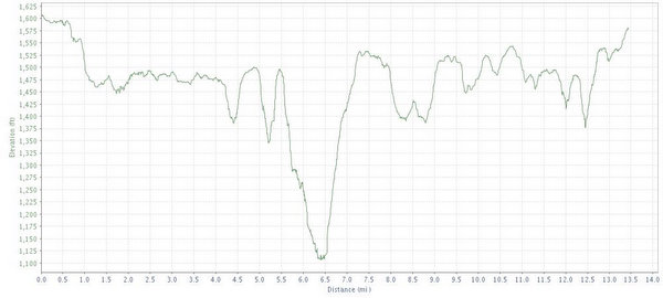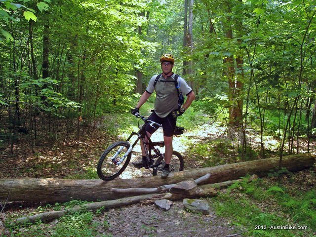
20+ miles of hard pack single track trails to explore the mountain side. TONS of fallen trees that you have to get over or around. Super fast and fun downhill sections. Some sections follow the oil pipeline downhill. Check your brakes before going. Fun place. Great flow and beautiful area. Nice and cool under all the trees.
Trail is very well marked, but you'll need a map as some trails are designated hiking only or biking only, some ATV trails as well, and the trials all connect and criss cross which is nice. Not sure where to get a map. We got ours from some campers, thankfully.
You don't want to end up at the bottom of a downhill section with no where to go but back up. Ridge trail was lots of fun, had a small rocky section that reminded us of Austin.
Location: Kennerdell, PA
Directions: From I -76 heading east - continue past the West Branch SP exit. I-76 will merge with I-80 - continue east into PA. Get off on RT8 which is Exit 29 - Franklin/Oil City - Make a left (north) on RT8 for about 5 miles - Get off at RT308 - which is Pearl/Bullion - Turn left and go a few hundred yards - Stay right and then turn right at the dead end (this is OLD RT8) -continue for a few miles - You will see a sign for Twin Oaks. Go right on Twin Oaks - go over bridge - the road will split - stay to the left. The next intersection is Dennison Run - go right. The parking lot with the wooden map will be about 100 yards up on the left.
Technical Level: Easy to Medium. Nothing too difficult. Fast downhills that will test your brakes and hand strength.