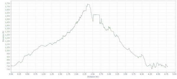
If you like to climb then this is a good place to go. The trail rises up, and up, and up before it gets to the top, loops around and then you can enjoy the spoils of your climb. For me, I'd rather have some up and down, but this is all up. As soon as you get to the top, you turn another corner and there is more climb.
Location: George Washington National Forest, just over the West Virginia eastern border.
Directions: Take highway 33 to SR613 and go left (southwest) to SR743. Got right on 743 and then left on 742. At SR933 go right and follow that into the Black Mountains. SR933 becomes route 225, stay on that until you come to the first set of gates. The trail head is right around there.
Technical Level: Medium - not a lot of technical challenges, but definitely a workout on the lungs. The Topo map looks like it is ~1000 feet of vertical climbing, maybe at best 750 feet.